As a northern lass who is accustomed to ‘calling a spade a bloody shovel’ I was left frustrated by what I saw and what I was told during the two days of this consultation. I returned on the second day to try to get clarification of things which had puzzled me when I looked at the information I had collected during the first day. Unfortunately the second day added to the confusion on most issues!
There is so much wrong with the proposed design, and the apparent thinking behind it, that it would be very easy to get side-tracked and waste energy on non-essential aspects. We need to keep focussed on 4 points.
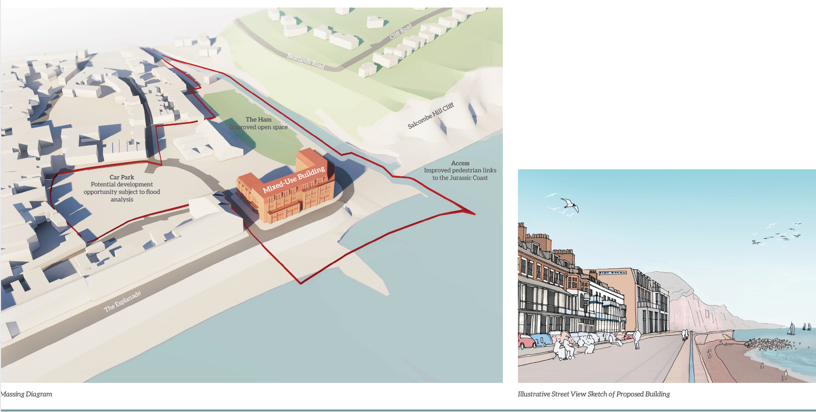
1) They are using Charity land which is protected.
The Ham land stretches from right up by the end of Riverside down to the sea. It was conveyed by Radford to the Urban District Council in 1896 to be used for recreation of visitors and inhabitants ‘for ever’. It was registered with the Charity Commissioners in the same year and the Conveyance now forms the governing document of the modern Charity No. 300967. The toilet block stands on Ham land and so does part of the proposed building! I can see how the toilet block with its shelter fits in with the Charity’ss aims, I can not see how a building created by a private developer to provide expensive flats does.
2) The Local Plan.
They have now discovered that around a third of the land, ED03, earmarked for regeneration to include 30 homes is not suitable for housing building on. Yet the allocation has not been downgraded.
In fact the whole of the area is in Flood Zone 3a which makes building anything anywhere on it a problem.
3) The needs of visitors and locals.
Over the years many ideas have turned up in surveys about what people would like to see on Port Royal to add facilities to the town; most importantly perhaps, some sort of wet weather facilities or activities for visitors and local youngsters. None of these aspirations have been included in the proposed design. Neither have any ideas from the competition last year.
Research from organisations like the Heritage Lottery Fund shows that a tourist attraction generates funds for the area, ‘Of every £1 spent on visiting a tourist attraction only 32p is spent at the actual attraction, the other 68p is spent in the surrounding area in shops and restaurants.’
4) Loss of current provision and of things of intangible value.
We don’t lose the activities associated with the Lifeboat or Sailing Club, but the boat park for the Sailing Club will have to be relocated.
There will be a loss of parking as at least 30 spaces will need to be allocated for the apartments, I believe this a legal requirement. More parking will be lost to accommodate the re-sited boats.
It loses more of the south end of the Ham to a) building which intrudes on land given to the town and is against the Conveyance covering the use of the Ham, b) boat storage which is against the Conveyance.
It loses about one third of the grassed area to hard-standing and an access road. This will have a knock-on effect on Folk Week and other activities which happen there.
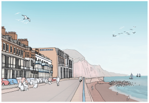
It loses views of the cliffs from along the whole of the Esplanade.
It loses views from the Esplanade back along the Sid Valley.
It loses visual value from what is already a unlovely end of town. Except during the height of summer (which is what the shadows on their drawings show ) the Ham and rear of the building will be in a great deal of shade.
The Ham as a gateway to the town from the Byes, or the Coastal Path, or the car park, loses the ‘feel’ of an historic town; and becomes less attractive to tourists.
I am sure you can think of many other things which will be a loss.
We need regeneration of the area, not to kill it off completely!
All this is being rushed through before the results of the Neighbourhood Plan are finalised and the Plan itself goes out for voting on. We don’t want any irrevocable decisions about the town until the Neighbourhood Plan is in place, whatever it turns out to be.
A final thought for this section.
The Beach Management Plan shortlisted 4 (plus 4a) possible solutions for consultation, the Re-imagining Port Royal competition had a short list too, yet only one possibility has been considered for Port Royal. Why?
Further information
For those of you interested in looking into this proposal in more depth I have tried to summarize the information in the section below. Despite my best efforts there is still quite a lot to take in. I have used blue text for my comments about the facts and quotes I give.
I am aware that many other clubs use the facilities at the Sailing Club, and they are all important. However, when writing about them as a whole I shall just use the term ‘Sailing Club’ to cover the lot. No offence is meant to anyone in those clubs.
When looking at the information given to us watch out for ‘weazel words’; that is those words which create impressions without facts or in any other way allow wriggle room for people to sneak their way out of things if necessary. There are quite a few!!!
What do the Consultation Boards tell us?
‘The consultants are undertaking their analysis by giving consideration to:
Any technical constraints and opportunities;
Planning policy (e.g. The Local Plan)
The financial feasibility of any proposals to ensure that only those redevelopment opportunities that have a ‘realistic’ possibility of coming forward should be considered. ‘
‘Sidmouth Town and East Devon District councils will be reviewing the findings of this consultation and the work of our professional advisors during the summer and will report to councillors later in the year. The Town Council will then consider how to progress.’
Summer runs from 21st June to 21st September, the survey closes on 31st July so the results can not be collated and properly assessed until mid August at the earliest. The Neighbourhood Plan survey closed on 30th June so their work will be about a month ahead and should be taken in to account.
‘The analysis that has so far been undertaken has identified some key constraints and opportunities. These have informed the location and arrangement of the redevelopment opportunities as shown on Board 3. These are set out below:
• The content of Strategy 26, 6. c) in the adopted East Devon Local Plan 2013 to 2031; Land at Port Royal Site: Land for residential use is allocated for 30 homes (site ED03) this site will incorporate mixed use redevelopment to include housing and community, commercial, recreation and other uses. (Note: the land outlined in blue on Board 1)
• Part of the Scoping Study Area is in the Conservation Area. Land adjacent to the site is also in the Conservation Area and there are listed buildings on the periphery of the Scoping Study Area.• All of the Scoping Study Area sits within Flood Zone 3a. This has been established following consultation with the Environment Agency.
• Certain uses within the Scoping Study Area need to be retained in their present location for various reasons, in particular the swimming pool complex and the Ham recreation ground.
• Existing parking provision within the Scoping Study Area should be retained where possible.
• The existing lifeboat station and sailing club need to have a waterfront location for operational reasons. (These are within the Allocated Site)
• There are no obvious technical reasons that would prevent the lifeboat station, sailing club, Drill Hall and toilet block from being demolished with an alternative development provided on that part of the Study Area.
There are no technical reasons why things could not be demolished and rebuilt, but there are legal reasons. Such as the terms of the Ham Conveyance and their own planning advice that the Drill Hall can’t be demolished; amongst others.
• Existing occupational leaseholders are integral to the delivery of development on the Allocated site.’
What does ‘occupational leaseholder’ mean? The only people who hold a lease for the purposes of their occupation/business are Sidmouth Trawlers. The Lifeboat is a voluntary service and the Sailing Club lease is for leisure use.
‘• The development could comprise a building of between 3 and 5 storeys. It could be a single building incorporating various uses including a new lifeboat station, a multifunction unit that could incorporate the sailing club, other water related clubs already operating, public toilets and wider community use. Space could also be created for a café and restaurant. These could occupy the ground floor and first floor of the building.
• Up to thirty residential apartments with potential to be of various sizes could form part of this development occupying the second, third and fourth floors.
• The concept proposals have been prepared taking into account the character of the existing site and immediate surrounding environment.’
The repeated use of the word ‘could’ means that they are making no commitment at this stage, but we are supposed to commit to accepting the block.
‘Ham Car Park and East Street Car Park
• Consideration has been given to the redevelopment of the Ham and East Street Car Parks. However, analysis of the Study Area from a flood risk perspective shows that much of it sits within Flood Zone 3a. This designation has been identified through discussion with the Environment Agency.’
• The planning process requires any development proposal to be carefully considered when it is proposed to be located within such a high risk flood zone. Further discussion will be required with both the Environment Agency and East Devon District Council planning department before any proposals can be taken forward.’
Earlier they say the whole of ED03 is in Flood Zone 3a, so surely this applies to the whole site?
‘• The sailing club have an operational requirement for boat storage. Therefore we have identified an area currently occupied by the existing sheds and retail unit to the rear of the sailing club, Drill Hall and toilet block which could be used for that purpose. To enable this to happen the existing occupiers would have to be relocated to alternative premises.’
The interests of leisure sailors takes precedence over people’s livelihood. Sidmouth Trawlers have repeatedly said they need the facilities they have built up there over the decades and that nowhere else can be made as suitable. They and their customers, including tourists, will lose out to an unlovely boat park; which will also create a Health and Safety hazard to the use of the Ham.
What was I told by senior EDDC and STC officers?
Some of these were contradictory.
3 floors of apartments are necessary to fund upgraded facilities for the Lifeboat and Sailing Club, nothing less. VERSUS 3 floors of apartments are not necessary if the apartments are very expensive and bring in enough money.
The Local Plan says ‘30 homes’ on the site. VERSUS The Local Plan says ‘up to 30 homes’ so we can have less than 30 without problem.
The proposed development is not in the Conservation Area VERSUS The development is in the Conservation Area.
The town wants this sort of regeneration at Port Royal, (but when asked for evidence of this sentiment none was forthcoming)
The town can reject this if they want, but if they do then the area will remain as it is. ( The tone of voice made it clear that the implication was ‘be left to rot’, and was accompanied by a shrug of the shoulders. )
The building will not look as big as it does in the illustrations shown, the apparent size is a trick of perspective. (!!!!)
The massing of the building is not available for change. VERSUS The massing of the building could change quite a lot so don’t take it too seriously, however the footprint plan can be relied on.
We should be aspiring to upgrade and expand the Lifeboat and Sailing facilities. Even though no-one could tell me what new sea-based activities had been suggested for this expanded provision. Every activity mentioned already uses the facilities.
Many groups already rent the Sailing Club facilities, outside events occur there several times a week. Therefore an upgrade to the facilities would benefit many outside the Club. (This information would need to be verified)
When asked about how the views of visitors would be collected the answer was a look of incomprehension, and a response that any visitors in town at the moment could give their opinion … but that it was considered that this was a decision for the town. If the town doesn’t consider visitors then visitors will stop coming and the town will die.
From these statements should we
a) assume incompetence on the part of the Officers?
b) assume that we are being lied to?
c) assume we are regarded as being stupid and they are trying, ineffectually, to simplify it?
or
d) assume that it is so complicated that even employed officials can’t get it straight in their heads? If so then this stage of the consultation should be extended until everyone understands it thoroughly, especially as we can’t ( under the terms of the Scoping Exercise) come back to it later.
What is missing?
Any reassessment of ED03 in the light of flood issues.
Consideration of shadows cast in winter, the ones shown are summer values.
Wind tunnel effect down Ham Lane and across the Ham.
Psychological effects of buildings which are not ‘human scale’.
Consideration that this is right up to the pavement where most of the other buildings are set back.
Firm commitments as to what would be provided for the Lifeboat, Sailing Club users, and Community.
Any consideration that minimal intervention could create a large effect. Currently EDDC own the land for the Sailing Club but the Club raised the money for the building and so own it. If the buildings need upgrading then the Club could do it privately.
EDDC own the Lifeboat land and buildings, any upgrades could be funded by subscription.
Matt Booth gave a costed business plan to EDDC several years ago suggesting that if an initial low rent was charged for the Drill Hall it could become a flourishing community hub and ultimately repay any concessions given at start-up. If it is viable for that purpose then it is viable for many other tourist uses. This sort of thing has been done successfully in many other tourist areas by both private business and Local Government.
An explanation of why the Sailing Club should be given larger premises in order that they might rent it out and make money.
What has been overlooked?
People complain about the stark feeling of the car parks, continuing them across into the Ham will make this worse.
A boat park is very ugly and impossible to disguise because of the masts which are 2 storeys high.
A five storey frontage means a six storey rear.
Trinity Court only got permission because the visual height is 3 storeys, the same as the other buildings in the row.
The effect on tourists and tourism.
No increased facilities to draw people to the town.
The serious effects caused by loss of parking.
No consideration of the effect a huge block would have in closing off the end of the town and making people shy away from it.
Loss of views when entering the town and from within the town.
What will be gained?
30 very expensive sea front apartments, and the associated income from rates.
A higher standard upgrade of facilities for Lifeboat and Sailing Club than is needed.
Perhaps a restaurant and or community space but no promises.
Lots of money for the Councils from selling a prime sea front site.
What will be lost?
A ‘typically English’ looking Lifeboat Station much appreciated by visitors (especially children as it looks just like what they see in books).
A solidly build Drill Hall which has proved how well it was built by withstanding decades of neglect with little effect on the structure. It is NOT falling down, just ugly through neglect. There is a large amount of space contained on its 3 floors and it could be turned to a variety of uses.
A Sailing Club building which is equally unlovely as it stands but could easily be made very interesting by adding a pitched roof to the 3rd floor and cladding the lower two floors and utilitarian metal supports for the 3rd floor, in keeping with the town architecture.
An adequate boat store for current needs.
Charity land (the Ham) which has as its charitable purpose that it ‘might be for ever used and enjoyed by the inhabitants of, and the visitors to, Sidmouth as a place of recreation freely and voluntarily,’, not that it might be off limits due to boats parked on it!
Part of the same Charity land, the block containing the toilets, being built on for the profit of Sidmouth Town and East Devon County Councils.
What aren’t they telling us?
That not only are the car parks not acceptable to build housing but that with the erosion at Pennington Point lower levels of any building on the higher part of site would have to reach stringent standards concerning possible flooding.
I have received specialist opinion that housing on the lower 2 floors would probably not be allowed even with such mitigating actions being taken ( a new sea wall would probably be necessary to meet required standards). Therefore, if they didn’t house non-residential activities on the lower floors there would probably be wasted space.
As this building is out of keeping with the Conservation Area, as far as massing and scale is concerned, it would adversely affect the setting of the World Heritage Site and would also not be likely to receive approval from Historic England.
The footprint of the proposed building trespasses on land which is not available for building.
The Drill Hall was built on the land level at that time so any archeological remains from the river delta would not have been disturbed. Investigation would be required before building permission could be obtained.
There may be interest from Industrial Archeologists concerning the remnants of the 1888 sewer system under the back of the Drill Hall and the Fishermen’s sheds ( Sidmouth Trawler yard )
Details of the Conveyence from Radford to the town.
To be continued!